|
|
|
Revealed:
The secret of Oak Island
by Laverne Johnson
|
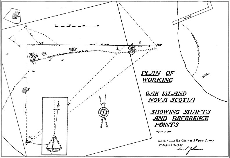
The Roper Survey did not coincide in any recognizable way with anything in Wilkins' book, but some people have tried, and still try, to convince themselves and others that there is a connection between the book and the island. The survey did pinpoint with precision three unusual marks. They were,
(1) a large triangle made of stones about three hundred feet directly south of the Money Pit area,
(2) a large stone with a hole drilled in its upper surface, about fifty feet north of the Money Pit area, and
(3) a similar drilled stone more than four hundred feet approximately east of the first drilled stone.
The triangle was first mentioned in 1897 when Captain Welling pointed it out to Fred Blair. Mr. Blair had come upon the drilled stone north of the Money pit in 1895. The drilled stone near Smith’s Cove was discovered by Mr. Hedden while he was trying to connect Oak Island with the treasure map in Wilkins' book.
R.V. Harris, in his book The Oak Island Mystery described the triangle as follows:
The most interesting discovery made by Mr. Hedden in this period was the mysterious triangle in the grass just above high-water mark on the south shore of the Island, which had been previously discovered by Captain Welling and Fred Blair in 1897.
This triangle was equilateral, each side measuring ten feet and was composed of large round beach stones; from a point on the base line, four feet from the west end of the line and six feet from the east end, ran a medial line, composed of beach stones connecting the point with the apex, and pointing directly to True North or the Pole Star, thus eliminating the variations of the magnetic compass.
There was also a curved line about three feet below the base and connecting both ends, the pointer line being extended southerly to meet the curved line, making the whole design resemble a giant sextant.
This triangle undoubtedly has some significance as the vertical line, or pointer, passes through the Money pit 210 feet away to the north.
Actually, taken from the Roper Survey the distance from the triangle to the Money Pit is approximately three hundred feet rather than two hundred feet, but obviously Mr. Harris had been given the two hundred and ten foot value by someone who was still trying to equate Oak Island with the treasure map in Wilkins' book. The westerly drilled stone lay approximately fifty feet north of the Money Pit, but of course when the Roper Survey was made nobody knew precisely where the original shaft lay.
It was agreed that the two drilled stones and the triangle must have lain in their existing positions for a very long time, and were no doubt connected in some way with the original depositors. Until 1959 nobody seemed to connect the marks to each other. It was impossible for them to have anything to do with telling anybody how to go about recovering anything from far down in the flooded depths, so they were either ignored or treated as an unsolved mystery. Some people have suggested that the big triangle was laid down to point the way to the deep filled-in shaft when the depositor returned, but at any time since the deposit was made it was easier to find the site of the shaft than the location of the triangle, or it would have been easier if the parade of searchers had not devastated the area where the shaft had been.
If some of the searchers had given more consideration to the large triangle and the drilled stone True North of the Money Pit area after the marks were first reported in 1895 and 1897 they could have come to some very interesting conclusions. They would have learned that a line running true North from the triangle apex ran through the Money Pit area and right through the drilled stone. If they had paused to consider that the triangle and the drilled stone were probably part of a code left by the depositor, they should have realized that since the depositor placed the triangle and drilled stone on a True North South line it was very probable that he placed the drilled stone True North of his shaft, and the triangle True South of it. With that knowledge they would have understood that the lost original shaft had lain along that line, and they would have had a better chance of finding it again.
We have to remember that the depositor was operating in a remote area on an uninhabited Island. There were no settlers living around the shores of Mahone Bay or on the islands in the bay, and he had no reason to believe that settlers might come into the area before he could manage to return and recover his deposit. Therefore he would see no necessity for setting up some kind of intricate code to confuse somebody. Whatever he did on the Island was done to serve his own purposes. It is true enough that he did drive the long flooding tunnel out to Smith’s Cove, but he did it to seal off his deep workings, not to confuse somebody who might be so shortsighted as to think that what was buried was buried down in the flooded depths. Likewise he did not place his code marks to confuse some searcher who might come along. He placed them to direct him to the exact spot where he would dig and recover the deposit. He must have considered his deposit worth all the work he went to, but he also knew how safely he had buried it, and he made his code as simple as he could with as little room for error as possible.
The depositor never intended to leave his treasure below tide level, and it would never have occurred to him that if some chance searcher did come along he would assume anything as ridiculous as a suspicion that the treasure lay in the flooded depths. The depositor did all that work to flood the depths simply to prevent any chance searcher from getting down into the depths and finding the beginning of the treasure tunnel running up into the high ground.
At some time prior to 1749 when settlers began to appear around Mahone Bay, a ship or ships, no longer sufficiently seaworthy to chance the Atlantic crossing, made their way into Mahone Bay and up to what became known as Oak Island. They carried cargo considered by them to be of great value, and it was deemed necessary to leave that cargo safely hidden on the Island until they could return for it in a seaworthy ship. Among those men was at least one man with the experience and ability to devise a suitable concealment for that valuable cargo. He may have been a relatively simple man, but he knew how to get things done.
He used the simplest plan he could devise that would give him absolute assurance that recovery of the deposit would be a relatively simple matter, but which would certainly foil any treasure hunters. Treasure hunters since 1795 have learned how successful his plan was.
The first part of his plan called for the digging of a deep shaft in which he would not encounter water. Perhaps he just used trial and error, but however the depositor managed it, he did dig a deep shaft without encountering water. Some people find it hard to believe that such a crew could dig such a deep shaft, something more than one hundred feet, but as a boy in Saskatchewan I remember one well, hand dug, that was one hundred and fifteen feet deep. I remember it because I recall hearing grown men talking about it and saying that when you stood at the bottom of it and looked up you could only see a crescent of light like a new moon because there was a bend in the shaft. That well was hand dug by early settlers, and they could not have been very experienced or they would have managed to keep their excavation straight as they went down. The significant thing about it is that they did manage to dig the well.
Through the ages men have sunk vertical shafts and driven horizontal or inclined tunnels almost at will. The biggest problem they encountered was water that they could not control. With no power driven pumps only a limited amount of water could be coped with. The workers at Oak Island sank the deep vertical shaft and drove the two inclined tunnels through hard dry clay, and because they did not encounter water until they were prepared for it at Smith’s Cove it was simply a labour intensive but routine undertaking.
Much has been made about the engineering expertise necessary to construct the flooding system to seal off the depths of the Money Pit, and there has been a good deal of conjecture regarding the purpose of the Cave-in-Pit, into which Mrs. Sellers' ox fell in 1878, and which was a necessary part of that system. The system was not complicated, but was just part of the mastermind’s simple overall plan.
 Perhaps to understand what did happen at Oak Island we should go back to the beginning. As the deep shaft was being dug ladders would be used to enter and leave the shaft. Partial platforms were set into the sides of the shaft at intervals to support those ladders. The shaft was put down to something over one hundred feet, and from the bottom of the shaft the treasure tunnel was driven up into the high ground, where the deposit was made. From a level slightly above the treasure tunnel the flooding tunnel would have entered the shaft. According to R.V. Harris, "On June 9,1897 the workmen at a depth of one hundred and eleven feet, found a well-defined opening on the side of the Pit two and a half feet wide, filled with beach stones, gravel and sand, the sand being on top. Through this opening the sea water flowed into the Pit with great force and pressure, undoubtedly the long sought water tunnel leading from the shore to the Money Pit." So many shafts had been dug in the immediate area, and so many tunnels had been driven in the same general area that we do not know if the pit mentioned was actually the site of the original shaft, or if the tunnel was actually the flooding tunnel, or whether it was one of the other tunnels into which the flooding tunnel had broken. It does not matter, but it does indicate that the flooding tunnel very likely entered the original shaft at approximately that level, and therefore that the treasure tunnel would have left the shaft a short distance lower down.
From the beginning the depositor intended to refill his deep shaft the way it was found in 1795 and l804. It was refilled with those platforms every ten feet in order to distribute the great weight of the fill so that it would not settle and plug off the exit of the flooding tunnel. He also intended to flood the depths, so he obviously had to have at least part of the flooding tunnel completed before he filled in the shaft. While the deep shaft and the treasure tunnel were being dug he set a crew to digging a second shaft about three hundred and fifty feet from the deep shaft, and along the line of the projected flooding tunnel. It was taken down to the depth below the surface at which the flooding tunnel would pass on its way from the shaft to the shore. The second shaft would stand to the side of where the flooding tunnel would pass, so that it could be refilled without blocking off the flooding tunnel. A tunnel was begun from the second shaft toward the deep shaft or Money Pit, and when the Money Pit and the treasure tunnel had been excavated men could begin tunnelling toward the shore to meet those coming from the second shaft. When that phase of the work was completed the Money Pit was refilled as it was found in 1795 and 1804. It had been a labourious but simple operation, done without any chance of premature flooding which could ruin the entire undertaking, and without danger of trapping workers down in the depths.
With the first phase completed the workers could begin safely driving the flooding tunnel out toward Smith’s Cove. As the tunnel approached the shore it came nearer to the surface, and at some point it was considered advisable to come up to tide level and then finish as an open cut.
I digress here to give a brief description of the large filter which supplied the water to the flooding tunnel. When the searchers first examined the beach they found that the beach stones and surface material had been stripped away from a large area between high and low tide. They found five branches or drains there converging to form one larger drain. The Halifax Colonist of January 2, 1864 reports, Perhaps to understand what did happen at Oak Island we should go back to the beginning. As the deep shaft was being dug ladders would be used to enter and leave the shaft. Partial platforms were set into the sides of the shaft at intervals to support those ladders. The shaft was put down to something over one hundred feet, and from the bottom of the shaft the treasure tunnel was driven up into the high ground, where the deposit was made. From a level slightly above the treasure tunnel the flooding tunnel would have entered the shaft. According to R.V. Harris, "On June 9,1897 the workmen at a depth of one hundred and eleven feet, found a well-defined opening on the side of the Pit two and a half feet wide, filled with beach stones, gravel and sand, the sand being on top. Through this opening the sea water flowed into the Pit with great force and pressure, undoubtedly the long sought water tunnel leading from the shore to the Money Pit." So many shafts had been dug in the immediate area, and so many tunnels had been driven in the same general area that we do not know if the pit mentioned was actually the site of the original shaft, or if the tunnel was actually the flooding tunnel, or whether it was one of the other tunnels into which the flooding tunnel had broken. It does not matter, but it does indicate that the flooding tunnel very likely entered the original shaft at approximately that level, and therefore that the treasure tunnel would have left the shaft a short distance lower down.
From the beginning the depositor intended to refill his deep shaft the way it was found in 1795 and l804. It was refilled with those platforms every ten feet in order to distribute the great weight of the fill so that it would not settle and plug off the exit of the flooding tunnel. He also intended to flood the depths, so he obviously had to have at least part of the flooding tunnel completed before he filled in the shaft. While the deep shaft and the treasure tunnel were being dug he set a crew to digging a second shaft about three hundred and fifty feet from the deep shaft, and along the line of the projected flooding tunnel. It was taken down to the depth below the surface at which the flooding tunnel would pass on its way from the shaft to the shore. The second shaft would stand to the side of where the flooding tunnel would pass, so that it could be refilled without blocking off the flooding tunnel. A tunnel was begun from the second shaft toward the deep shaft or Money Pit, and when the Money Pit and the treasure tunnel had been excavated men could begin tunnelling toward the shore to meet those coming from the second shaft. When that phase of the work was completed the Money Pit was refilled as it was found in 1795 and 1804. It had been a labourious but simple operation, done without any chance of premature flooding which could ruin the entire undertaking, and without danger of trapping workers down in the depths.
With the first phase completed the workers could begin safely driving the flooding tunnel out toward Smith’s Cove. As the tunnel approached the shore it came nearer to the surface, and at some point it was considered advisable to come up to tide level and then finish as an open cut.
I digress here to give a brief description of the large filter which supplied the water to the flooding tunnel. When the searchers first examined the beach they found that the beach stones and surface material had been stripped away from a large area between high and low tide. They found five branches or drains there converging to form one larger drain. The Halifax Colonist of January 2, 1864 reports,
In investigating the drains, they found that they connected with one of larger dimensions, the stones forming which had been prepared with a hammer, and were mechanically laid in such a way that the drain could not collapse. There was a number of tiers of stones strengthening the higher part of the drain, on top of which was also found a coating of the same kind of grass as that already noticed. Over it came a layer of blue sand such as before had not been seen on the Island, and over which was spread the gravel indigenous to the coast.
Having laid bare the large drain for a short distance into the bank, they found it had been so well made and protected that no earth had sifted through the arch to obstruct the water passing through it.
They then attempted to follow the inward direction of the drain, in search of a perpendicular shaft but on account of the surrounding soil being so soft, and so much saturated with water, it was given up as impracticable.
In his Oak Island books, R.V. Harris tells us that the five branch drains were boxed in with flat rocks making the drains about eight inches wide. They were probably not more than ten inches high. It is of interest to note that five drains, each eight by ten inches would only supply a main drain twenty by twenty inches. The flooding tunnel coming up from the Money Pit had to be large enough for men to work in, but once they broke out into that open cut they could finish off with that boxed in drain of relatively limited size. There was no need for the lower part of the large boxed in drain to be below low tide level, and there would be little problem of having to work in, or hold back the water while working.
With the flooding tunnel brought out to the beach and finished off as the large boxed in drain, nothing remained to be done but to construct the large filter. With the rest of the work completed, all the men were available to take part in this final phase. One can picture a long line of men standing at the high tide mark, almost shoulder to shoulder. As the tide ebbs they stay close behind it, passing as much material as possible back up above high tide level. Then as the tide comes in they work just ahead of it, still passing material back up the beach. Working in this manner, it would take surprisingly few tides to complete the filter as the searchers found it in 1849, and there would have been no necesssity for anybody to become very wet.
It should be easy to realize how simple and straight forward the entire project at Oak Island really was. It was not a fantastic engineering enterprise, and surely we can be confident that the man who engineered those works would be quite capable of working out a system just as straight forward in order to recover his deposit.
The depositor, being the kind of man who could carry out all the Oak Island works, was simply too clever to ever consider storing his deposit far down in the flooded depths from which he would have no chance of ever retrieving it. He must have tunnelled back up into the high ground above tide level to conceal it there.
 As I studied the available reports in the 1950s, it becomes obvious that the marks pinpointed by the surveyor Roper, the triangle and the drilled stones, must in some way have something to do with telling where, in the high ground, the treasure must still be lying safe and undisturbed. It all seems very simple and straightforward now, but at that moment I had no way of knowing what the marks meant, or whether other essential marks had been destroyed since 1795. Harris' book stated that the vertical line or pointer of the triangle passed through the Money Pit, but it had already stated that the precise location of the original shaft had been lost. I needed a copy of the Roper Survey, and when I asked for it, M.R. Chappell very kindly sent me a photocopy of it. I soon realized that a line running true north from the apex of the triangle passed through the southern portion of the 1937 Hedden shaft and through the drilled stone north of the Money Pit area. It would be logical to assume that the original shaft also lay along that line, but I had no way of knowing where, along the line, it had lain.
In time I realized that although the vertical line or pointer of the triangle pointed to the Money Pit and the drilled stone, the triangle itself was cocked in such a way that the whole triangle pointed about six and a half degrees west of true north. It was impossible to calculate the angle precisely because the triangle was simply a rough outline of irregular stones, but it did seem very likely that the triangle pointed up into the high ground toward the location of the buried deposit.
Assuming that the triangle did produce a line running up into the high ground to the treasure site, there would have to be something to tell the precise bearing of that line, and also just how far along that line the treasure site lay. It seemed very possible that there were marks missing, but I could only continue to pore over the puzzle. Eventually I felt that the best way to define some point along the line from the triangle would be for the depositor to produce a second line, which would intersect the first line at the significant spot. Gradually a code was beginning to appear in which the depositor used no linear measurements, only compass bearings. Such a code would certainly eliminate the possibility of somebody making an error in measuring the length of the necessary lines.
If the developing code used only degrees or angles it seemed possible that the depositor would have driven his tunnel up into the high ground on a magnetic north bearing, and that one of the intersecting lines would follow that same bearing from the deep shaft to the intersection with the line from the triangle. It was an intriguing concept, but I did not know where along the true north/south line the original shaft had been located, and I did not know what magnetic north may have been at Oak Island when the deposit was made.
Because settlers were moving into the Mahone Bay area by 1750, and because the native red oaks have a life span of about two hundred and fifty years, it seemed reasonable to assume that the deposit was made between the early 1600s and 1750. Enquiry from the Department of Energy Mines and Resources in Ottawa indicated that the magnetic declination of the compass for those years was probably between 12 degrees, 24 minutes and 15 degrees, with a reliability factor of up to plus or minus 5 degrees. In other words I could not tell within several degrees what magnetic north at Oak Island was for the time of deposit. Things were coming together, but it looked as though I had reached an impasse. I still had nothing that would give me any precision. It began to look as though the depositor used magnetic north in making his concealment, but he may or may not have used it when he returned for his treasure.
I needed some value that would give me the bearing for the precise direction of the treasure tunnel, but I also needed something to tell me where, along the true north/south line the original shaft had been. What I had learned so far had taken months, and I still lacked vital information that would make the code complete, but I had no way of knowing where to look for it or if it still existed on the Island.
I had never given much thought to the second drilled stone which lay far easterly toward Smith’s Cove, and which Roper had pinpointed in 1937. I realized that that stone must be a significant part of the code and might provide the information I needed so vitally. Perhaps the line between that stone and the other one ran at a significant bearing that in some way set up a very precise datum line which brought everything into place. I knew the line did not run true east/west, but I also knew that it was not far off it. Could it be that it lay half way between true east/west and magnetic east/west at the time of deposit? The more I thought about the actions of the depositor the more painstaking and precise he appeared to have been, and if he did in fact make the line between the two drilled stones a datum line half way between true and magnetic, it would definitely make the code more simple, and because the two stones were so far apart it was extremely unlikely that they would ever be recognized as part of a code. Finally I felt I could understand the principle of the code.
The depositor drove his treasure tunnel toward the north on a magnetic north bearing, and although he did not leave any mark on the surface to indicate where his treasure was buried at the upper end of the tunnel he did know how far away from the Money Pit it lay.
When the time came to set up his code he began by running a line easterly from the Money Pit at a right angle to the direction of the treasure tunnel. He ran that line more than four hundred feet, and there he set what we call the easterly drilled stone. From that drilled stone he ran a second line back westerly on a bearing half way between the first line and a true east/west line. At the point where the line came true north of the Money Pit he set the westerly drilled stone. Then he extended that line on westward to a point where a line running northward from it at a right angle would intersect the line from the Money Pit at the point beneath which the treasure lay. To make his code less conspicuous he did not set a mark at the right angle, but instead he ran a line southward at a right angle to the extended line between the drilled stones. One could say that he extended the line from the intersection southward through the second right angle and on down to a point where it came true south of the Money Pit, and there he set the apex stone for the large stone triangle which he constructed, and which has puzzled so many people for so long. His entire code consisted of the mark in the layer of flagstones at the Money Pit, the triangle, and the two drilled stones. Nothing could make it more complete.
Measured on the Roper survey, a line from the easterly drilled stone through the westerly drilled stone runs seven degrees south of true west. A line seven degrees south of the line between the two drilled stones would run fourteen degrees south of true west, and that would approximate very closely magnetic west for the time of deposit. It is noteworthy that that line, fourteen degrees south of true west, would cross the true north line in the southern part of the 1937 Hedden shaft.
Because the line between the two drilled stones ran seven degrees south of true west, the triangle must point seven degrees west of true north, and those lines must meet at a right angle. It would appear that the depositor based his code on a magnetic north fourteen degrees west of true north, but it is also possible, though not probable, that he just chose fourteen degrees as an arbitrary figure or value. The code would apply just as well in either case.
The first searchers in 1795 reported coming upon the layer of flagstones just below the surface of the shaft. If the depositor had been able to return for his deposit he would not have had to concern himself with true north or magnetic north. He would have begun his retrieval operation by uncovering the layer of flagstones, and locating the drilled stones and the big triangle. We cannot prove that there was some kind of mark or pattern on those flagstones, but that is the only reason they would have been brought there and set in the top of the shaft. He would have run a line from the easterly drilled stone to the mark on the layer of flagstones. From that mark he would run a line northerly at a right angle to the first line. That would re-establish the line of the treasure tunnel. Then he would run a line between the two drilled stones, and he would extend it on westerly to a point where a line running southerly from it at a right angle to it would cross the apex of the triangle. All that remained to be done was to run the line northerly from the triangle, through the point where it formed the second right angle, and carry it on until it intersected the line coming up from the layer of flagstones at the shaft. That would put him directly above the spot where his treasure lay, high and dry and safe above any flooding waters.
There is no evidence that the depositor ever returned to retrieve his deposit. If he had come back the remains of his recovery shaft would have been much more noticeable than was the depression under the oak tree in 1795. Some people have suggested that somebody who came back to retrieve the treasure just might have filled in the recovery shaft for some reason, but there is no conceivable reason why they would have done that. The thing uppermost in their minds after getting the treasure safely aboard their ship would have been to get away out of Mahone Bay before they could be intercepted and taken by some hostile ship.
The depositors completed their work to their satisfaction before they left Oak Island. The deep shaft was filled in and the layer of flagstones was set just below the surface. The filter at Smith’s Cove was completed, and the beach material that had been cleaned off was spread back to cover and protect the filter; the code marks had been carefully plotted and placed. There was no emergency that made them quit the Island, but their work was finished and it was time for them to leave. To this day, the treasure remains. As I studied the available reports in the 1950s, it becomes obvious that the marks pinpointed by the surveyor Roper, the triangle and the drilled stones, must in some way have something to do with telling where, in the high ground, the treasure must still be lying safe and undisturbed. It all seems very simple and straightforward now, but at that moment I had no way of knowing what the marks meant, or whether other essential marks had been destroyed since 1795. Harris' book stated that the vertical line or pointer of the triangle passed through the Money Pit, but it had already stated that the precise location of the original shaft had been lost. I needed a copy of the Roper Survey, and when I asked for it, M.R. Chappell very kindly sent me a photocopy of it. I soon realized that a line running true north from the apex of the triangle passed through the southern portion of the 1937 Hedden shaft and through the drilled stone north of the Money Pit area. It would be logical to assume that the original shaft also lay along that line, but I had no way of knowing where, along the line, it had lain.
In time I realized that although the vertical line or pointer of the triangle pointed to the Money Pit and the drilled stone, the triangle itself was cocked in such a way that the whole triangle pointed about six and a half degrees west of true north. It was impossible to calculate the angle precisely because the triangle was simply a rough outline of irregular stones, but it did seem very likely that the triangle pointed up into the high ground toward the location of the buried deposit.
Assuming that the triangle did produce a line running up into the high ground to the treasure site, there would have to be something to tell the precise bearing of that line, and also just how far along that line the treasure site lay. It seemed very possible that there were marks missing, but I could only continue to pore over the puzzle. Eventually I felt that the best way to define some point along the line from the triangle would be for the depositor to produce a second line, which would intersect the first line at the significant spot. Gradually a code was beginning to appear in which the depositor used no linear measurements, only compass bearings. Such a code would certainly eliminate the possibility of somebody making an error in measuring the length of the necessary lines.
If the developing code used only degrees or angles it seemed possible that the depositor would have driven his tunnel up into the high ground on a magnetic north bearing, and that one of the intersecting lines would follow that same bearing from the deep shaft to the intersection with the line from the triangle. It was an intriguing concept, but I did not know where along the true north/south line the original shaft had been located, and I did not know what magnetic north may have been at Oak Island when the deposit was made.
Because settlers were moving into the Mahone Bay area by 1750, and because the native red oaks have a life span of about two hundred and fifty years, it seemed reasonable to assume that the deposit was made between the early 1600s and 1750. Enquiry from the Department of Energy Mines and Resources in Ottawa indicated that the magnetic declination of the compass for those years was probably between 12 degrees, 24 minutes and 15 degrees, with a reliability factor of up to plus or minus 5 degrees. In other words I could not tell within several degrees what magnetic north at Oak Island was for the time of deposit. Things were coming together, but it looked as though I had reached an impasse. I still had nothing that would give me any precision. It began to look as though the depositor used magnetic north in making his concealment, but he may or may not have used it when he returned for his treasure.
I needed some value that would give me the bearing for the precise direction of the treasure tunnel, but I also needed something to tell me where, along the true north/south line the original shaft had been. What I had learned so far had taken months, and I still lacked vital information that would make the code complete, but I had no way of knowing where to look for it or if it still existed on the Island.
I had never given much thought to the second drilled stone which lay far easterly toward Smith’s Cove, and which Roper had pinpointed in 1937. I realized that that stone must be a significant part of the code and might provide the information I needed so vitally. Perhaps the line between that stone and the other one ran at a significant bearing that in some way set up a very precise datum line which brought everything into place. I knew the line did not run true east/west, but I also knew that it was not far off it. Could it be that it lay half way between true east/west and magnetic east/west at the time of deposit? The more I thought about the actions of the depositor the more painstaking and precise he appeared to have been, and if he did in fact make the line between the two drilled stones a datum line half way between true and magnetic, it would definitely make the code more simple, and because the two stones were so far apart it was extremely unlikely that they would ever be recognized as part of a code. Finally I felt I could understand the principle of the code.
The depositor drove his treasure tunnel toward the north on a magnetic north bearing, and although he did not leave any mark on the surface to indicate where his treasure was buried at the upper end of the tunnel he did know how far away from the Money Pit it lay.
When the time came to set up his code he began by running a line easterly from the Money Pit at a right angle to the direction of the treasure tunnel. He ran that line more than four hundred feet, and there he set what we call the easterly drilled stone. From that drilled stone he ran a second line back westerly on a bearing half way between the first line and a true east/west line. At the point where the line came true north of the Money Pit he set the westerly drilled stone. Then he extended that line on westward to a point where a line running northward from it at a right angle would intersect the line from the Money Pit at the point beneath which the treasure lay. To make his code less conspicuous he did not set a mark at the right angle, but instead he ran a line southward at a right angle to the extended line between the drilled stones. One could say that he extended the line from the intersection southward through the second right angle and on down to a point where it came true south of the Money Pit, and there he set the apex stone for the large stone triangle which he constructed, and which has puzzled so many people for so long. His entire code consisted of the mark in the layer of flagstones at the Money Pit, the triangle, and the two drilled stones. Nothing could make it more complete.
Measured on the Roper survey, a line from the easterly drilled stone through the westerly drilled stone runs seven degrees south of true west. A line seven degrees south of the line between the two drilled stones would run fourteen degrees south of true west, and that would approximate very closely magnetic west for the time of deposit. It is noteworthy that that line, fourteen degrees south of true west, would cross the true north line in the southern part of the 1937 Hedden shaft.
Because the line between the two drilled stones ran seven degrees south of true west, the triangle must point seven degrees west of true north, and those lines must meet at a right angle. It would appear that the depositor based his code on a magnetic north fourteen degrees west of true north, but it is also possible, though not probable, that he just chose fourteen degrees as an arbitrary figure or value. The code would apply just as well in either case.
The first searchers in 1795 reported coming upon the layer of flagstones just below the surface of the shaft. If the depositor had been able to return for his deposit he would not have had to concern himself with true north or magnetic north. He would have begun his retrieval operation by uncovering the layer of flagstones, and locating the drilled stones and the big triangle. We cannot prove that there was some kind of mark or pattern on those flagstones, but that is the only reason they would have been brought there and set in the top of the shaft. He would have run a line from the easterly drilled stone to the mark on the layer of flagstones. From that mark he would run a line northerly at a right angle to the first line. That would re-establish the line of the treasure tunnel. Then he would run a line between the two drilled stones, and he would extend it on westerly to a point where a line running southerly from it at a right angle to it would cross the apex of the triangle. All that remained to be done was to run the line northerly from the triangle, through the point where it formed the second right angle, and carry it on until it intersected the line coming up from the layer of flagstones at the shaft. That would put him directly above the spot where his treasure lay, high and dry and safe above any flooding waters.
There is no evidence that the depositor ever returned to retrieve his deposit. If he had come back the remains of his recovery shaft would have been much more noticeable than was the depression under the oak tree in 1795. Some people have suggested that somebody who came back to retrieve the treasure just might have filled in the recovery shaft for some reason, but there is no conceivable reason why they would have done that. The thing uppermost in their minds after getting the treasure safely aboard their ship would have been to get away out of Mahone Bay before they could be intercepted and taken by some hostile ship.
The depositors completed their work to their satisfaction before they left Oak Island. The deep shaft was filled in and the layer of flagstones was set just below the surface. The filter at Smith’s Cove was completed, and the beach material that had been cleaned off was spread back to cover and protect the filter; the code marks had been carefully plotted and placed. There was no emergency that made them quit the Island, but their work was finished and it was time for them to leave. To this day, the treasure remains.
|
|
![[Grand Lodge]](../../images/hedn.jpg)